


python遥感图像裁剪成深度学习样本_支持多波段

前言
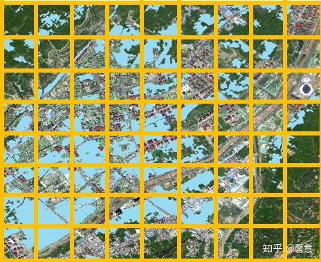
如果将图像直接输入到深度学习网络中,会导致 内存溢出 ,因此需要将图像裁剪成图像块输入到网络中。裁剪方法包括 规则格网裁剪 和 滑动窗口裁剪 以及 随机裁剪 。


正文
规则格网裁剪属于重复率为0的滑动窗口裁剪,滑动窗口裁剪代码为:
import os
import gdal
import numpy as np
# 读取tif数据集
def readTif(fileName):
dataset = gdal.Open(fileName)
if dataset == None:
print(fileName + "文件无法打开")
return dataset
# 保存tif文件函数
def writeTiff(im_data, im_geotrans, im_proj, path):
if 'int8' in im_data.dtype.name:
datatype = gdal.GDT_Byte
elif 'int16' in im_data.dtype.name:
datatype = gdal.GDT_UInt16
else:
datatype = gdal.GDT_Float32
if len(im_data.shape) == 3:
im_bands, im_height, im_width = im_data.shape
elif len(im_data.shape) == 2:
im_data = np.array([im_data])
im_bands, im_height, im_width = im_data.shape
#创建文件
driver = gdal.GetDriverByName("GTiff")
dataset = driver.Create(path, int(im_width), int(im_height), int(im_bands), datatype)
if(dataset!= None):
dataset.SetGeoTransform(im_geotrans) #写入仿射变换参数
dataset.SetProjection(im_proj) #写入投影
for i in range(im_bands):
dataset.GetRasterBand(i + 1).WriteArray(im_data[i])
del dataset
滑动窗口裁剪函数
TifPath 影像路径
SavePath 裁剪后保存目录
CropSize 裁剪尺寸
RepetitionRate 重复率
def TifCrop(TifPath, SavePath, CropSize, RepetitionRate):
dataset_img = readTif(TifPath)
width = dataset_img.RasterXSize
height = dataset_img.RasterYSize
proj = dataset_img.GetProjection()
geotrans = dataset_img.GetGeoTransform()
img = dataset_img.ReadAsArray(0, 0, width, height)#获取数据
# 获取当前文件夹的文件个数len,并以len+1命名即将裁剪得到的图像
new_name = len(os.listdir(SavePath)) + 1
# 裁剪图片,重复率为RepetitionRate
for i in range(int((height - CropSize * RepetitionRate) / (CropSize * (1 - RepetitionRate)))):
for j in range(int((width - CropSize * RepetitionRate) / (CropSize * (1 - RepetitionRate)))):
# 如果图像是单波段
if(len(img.shape) == 2):
cropped = img[int(i * CropSize * (1 - RepetitionRate)) : int(i * CropSize * (1 - RepetitionRate)) + CropSize,
int(j * CropSize * (1 - RepetitionRate)) : int(j * CropSize * (1 - RepetitionRate)) + CropSize]
# 如果图像是多波段
else:
cropped = img[:,
int(i * CropSize * (1 - RepetitionRate)) : int(i * CropSize * (1 - RepetitionRate)) + CropSize,
int(j * CropSize * (1 - RepetitionRate)) : int(j * CropSize * (1 - RepetitionRate)) + CropSize]
# 写图像
writeTiff(cropped, geotrans, proj, SavePath + "/%d.tif"%new_name)
# 文件名 + 1
new_name = new_name + 1
# 向前裁剪最后一列
for i in range(int((height-CropSize*RepetitionRate)/(CropSize*(1-RepetitionRate)))):
if(len(img.shape) == 2):
cropped = img[int(i * CropSize * (1 - RepetitionRate)) : int(i * CropSize * (1 - RepetitionRate)) + CropSize,
(width - CropSize) : width]
else:
cropped = img[:,
int(i * CropSize * (1 - RepetitionRate)) : int(i * CropSize * (1 - RepetitionRate)) + CropSize,
(width - CropSize) : width]
# 写图像
writeTiff(cropped, geotrans, proj, SavePath + "/%d.tif"%new_name)
new_name = new_name + 1
# 向前裁剪最后一行
for j in range(int((width - CropSize * RepetitionRate) / (CropSize * (1 - RepetitionRate)))):
if(len(img.shape) == 2):
cropped = img[(height - CropSize) : height,
int(j * CropSize * (1 - RepetitionRate)) : int(j * CropSize * (1 - RepetitionRate)) + CropSize]
else:
cropped = img[:,
(height - CropSize) : height,
int(j * CropSize * (1 - RepetitionRate)) : int(j * CropSize * (1 - RepetitionRate)) + CropSize]
writeTiff(cropped, geotrans, proj, SavePath + "/%d.tif"%new_name)
# 文件名 + 1
new_name = new_name + 1
# 裁剪右下角
if(len(img.shape) == 2):
cropped = img[(height - CropSize) : height,
(width - CropSize) : width]
else:
cropped = img[:,
(height - CropSize) : height,
(width - CropSize) : width]
writeTiff(cropped, geotrans, proj, SavePath + "/%d.tif"%new_name)
new_name = new_name + 1
# 将影像1裁剪为重复率为0.1的256×256的数据集
TifCrop(r"Data\data2\tif\data2.tif",
r"Data\train\image1", 256, 0.1)
TifCrop(r"Data\data2\label\label.tif",
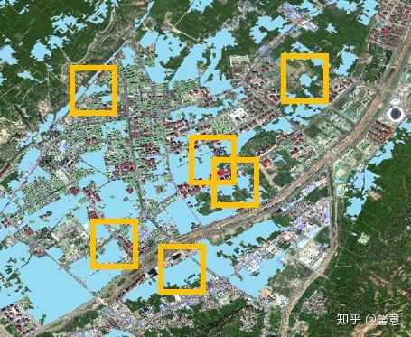
r"data\train\label1", 256, 0.1)随机裁剪的话,只需要 随机生成裁剪图像的左上角坐标,然后以此为基准取特定大小的矩阵块 就可以了。代码:
import random
import gdal
import numpy as np
import os
#  读取tif数据集
def readTif(fileName):
    dataset = gdal.Open(fileName)
    if dataset == None:
        print(fileName + "文件无法打开")
    return dataset
#  保存tif文件函数
def writeTiff(im_data, im_geotrans, im_proj, path):
    if 'int8' in im_data.dtype.name:
        datatype = gdal.GDT_Byte
    elif 'int16' in im_data.dtype.name:
        datatype = gdal.GDT_UInt16
    else:
        datatype = gdal.GDT_Float32
    if len(im_data.shape) == 3:
        im_bands, im_height, im_width = im_data.shape
    elif len(im_data.shape) == 2:
        im_data = np.array([im_data])
        im_bands, im_height, im_width = im_data.shape
    #创建文件
    driver = gdal.GetDriverByName("GTiff")
    dataset = driver.Create(path, int(im_width), int(im_height), int(im_bands), datatype)
    if(dataset!= None):
        dataset.SetGeoTransform(im_geotrans) #写入仿射变换参数
        dataset.SetProjection(im_proj) #写入投影
    for i in range(im_bands):
        dataset.GetRasterBand(i + 1).WriteArray(im_data[i])
    del dataset
随机裁剪函数
ImagePath 原始影像路径
LabelPath 标签影像路径
IamgeSavePath 原始影像裁剪后保存目录
LabelSavePath 标签影像裁剪后保存目录
CropSize 裁剪尺寸
CutNum 裁剪数量
def RandomCrop(ImagePath, LabelPath, IamgeSavePath, LabelSavePath, CropSize, CutNum):
    dataset_img = readTif(ImagePath)
    width = dataset_img.RasterXSize
    height = dataset_img.RasterYSize
    proj = dataset_img.GetProjection()
    geotrans = dataset_img.GetGeoTransform()
    img = dataset_img.ReadAsArray(0,0,width,height)#获取哟昂数据
    dataset_label = readTif(LabelPath)
    label = dataset_label.ReadAsArray(0,0,width,height)#获取标签数据
    #  获取当前文件夹的文件个数len,并以len+1命名即将裁剪得到的图像
    fileNum = len(os.listdir(IamgeSavePath))
    new_name = fileNum + 1
    while(new_name < CutNum + fileNum + 1):
        #  生成剪切图像的左上角XY坐标
        UpperLeftX = random.randint(0, height - CropSize)
        UpperLeftY = random.randint(0, width - CropSize)
        if(len(img.shape) == 2):
            imgCrop = img[UpperLeftX : UpperLeftX + CropSize,
                          UpperLeftY : UpperLeftY + CropSize]
        else:
            imgCrop = img[:,
                          UpperLeftX : UpperLeftX + CropSize,
                          UpperLeftY : UpperLeftY + CropSize]
        if(len(label.shape) == 2):
            labelCrop = label[UpperLeftX : UpperLeftX + CropSize,
                              UpperLeftY : UpperLeftY + CropSize]
        else:
            labelCrop = label[:,
                              UpperLeftX : UpperLeftX + CropSize,
                              UpperLeftY : UpperLeftY + CropSize]
        writeTiff(imgCrop, geotrans, proj, IamgeSavePath + "/%d.tif"%new_name)
        writeTiff(labelCrop, geotrans, proj, LabelSavePath + "/%d.tif"%new_name)
        new_name = new_name + 1
#  裁剪得到300张256*256大小的训练集
RandomCrop(r"Data\data2\tif\data2.tif",
           r"Data\data2\label\label.tif",
           r"Data\train\image1",
           r"Data\train\label1",
           256,300)
后记
裁剪好了就可以语义分割了
欢迎留言交流~
添加地理坐标
本来如果裁剪只是做样本的话是用不到坐标信息的,因为深度学习只是学习的像素,学习不了坐标。但是好多同学留言加上坐标信息,其实加上坐标信息只需要利用仿射变换矩阵计算裁剪的样本的左上角的坐标,然后更新新的仿射变换矩阵就可以了。代码:
import os
    import gdal
except :
    from osgeo import gdal
import numpy as np
# 读取tif数据集
def readTif(fileName):
    dataset = gdal.Open(fileName)
    if dataset == None:
        print(fileName + "文件无法打开")
    return dataset
# 保存tif文件函数
def writeTiff(im_data, im_geotrans, im_proj, path):
    if 'int8' in im_data.dtype.name:
        datatype = gdal.GDT_Byte
    elif 'int16' in im_data.dtype.name:
        datatype = gdal.GDT_UInt16
    else:
        datatype = gdal.GDT_Float32
    if len(im_data.shape) == 3:
        im_bands, im_height, im_width = im_data.shape
    elif len(im_data.shape) == 2:
        im_data = np.array([im_data])
        im_bands, im_height, im_width = im_data.shape
    # 创建文件
    driver = gdal.GetDriverByName("GTiff")
    dataset = driver.Create(path, int(im_width), int(im_height), int(im_bands), datatype)
    if(dataset!= None):
        dataset.SetGeoTransform(im_geotrans) # 写入仿射变换参数
        dataset.SetProjection(im_proj) # 写入投影
    for i in range(im_bands):
        dataset.GetRasterBand(i + 1).WriteArray(im_data[i])
    del dataset
# 像素坐标和地理坐标仿射变换
def CoordTransf(Xpixel, Ypixel, GeoTransform):
    XGeo = GeoTransform[0]+GeoTransform[1]*Xpixel+Ypixel*GeoTransform[2];
    YGeo = GeoTransform[3]+GeoTransform[4]*Xpixel+Ypixel*GeoTransform[5];
    return XGeo, YGeo
滑动窗口裁剪函数
TifPath 影像路径
SavePath 裁剪后保存目录
CropSize 裁剪尺寸
RepetitionRate 重复率
def TifCrop(TifPath, SavePath, CropSize, RepetitionRate):
    if not os.path.exists(SavePath): os.makedirs(SavePath)
    dataset_img = readTif(TifPath)
    width = dataset_img.RasterXSize
    height = dataset_img.RasterYSize
    proj = dataset_img.GetProjection()
    geotrans = dataset_img.GetGeoTransform()
    img = dataset_img.ReadAsArray(0, 0, width, height)# 获取数据
    # 获取当前文件夹的文件个数len,并以len+1命名即将裁剪得到的图像
    new_name = len(os.listdir(SavePath)) + 1
    # 裁剪图片,重复率为RepetitionRate
    for i in range(int((height - CropSize * RepetitionRate) / (CropSize * (1 - RepetitionRate)))):
        for j in range(int((width - CropSize * RepetitionRate) / (CropSize * (1 - RepetitionRate)))):
            # 如果图像是单波段
            if(len(img.shape) == 2):
                cropped = img[int(i * CropSize * (1 - RepetitionRate)) : int(i * CropSize * (1 - RepetitionRate)) + CropSize,
                              int(j * CropSize * (1 - RepetitionRate)) : int(j * CropSize * (1 - RepetitionRate)) + CropSize]
            # 如果图像是多波段
            else:
                cropped = img[:,
                              int(i * CropSize * (1 - RepetitionRate)) : int(i * CropSize * (1 - RepetitionRate)) + CropSize,
                              int(j * CropSize * (1 - RepetitionRate)) : int(j * CropSize * (1 - RepetitionRate)) + CropSize]
            XGeo, YGeo = CoordTransf(int(j * CropSize * (1 - RepetitionRate)),
                                     int(i * CropSize * (1 - RepetitionRate)),
                                     geotrans)
            crop_geotrans = (XGeo, geotrans[1], geotrans[2], YGeo, geotrans[4], geotrans[5])
            # 写图像
            writeTiff(cropped, crop_geotrans, proj, SavePath + "/%d.tif"%new_name)
            # 文件名 + 1
            new_name = new_name + 1
    # 向前裁剪最后一列
    for i in range(int((height-CropSize*RepetitionRate)/(CropSize*(1-RepetitionRate)))):
        if(len(img.shape) == 2):
            cropped = img[int(i * CropSize * (1 - RepetitionRate)) : int(i * CropSize * (1 - RepetitionRate)) + CropSize,
                          (width - CropSize) : width]
        else:
            cropped = img[:,
                          int(i * CropSize * (1 - RepetitionRate)) : int(i * CropSize * (1 - RepetitionRate)) + CropSize,
                          (width - CropSize) : width]
        XGeo, YGeo = CoordTransf(width - CropSize,
                                 int(i * CropSize * (1 - RepetitionRate)),
                                 geotrans)
        crop_geotrans = (XGeo, geotrans[1], geotrans[2], YGeo, geotrans[4], geotrans[5])
        # 写图像
        writeTiff(cropped, crop_geotrans, proj, SavePath + "/%d.tif"%new_name)
        new_name = new_name + 1
    # 向前裁剪最后一行
    for j in range(int((width - CropSize * RepetitionRate) / (CropSize * (1 - RepetitionRate)))):
        if(len(img.shape) == 2):
            cropped = img[(height - CropSize) : height,
                          int(j * CropSize * (1 - RepetitionRate)) : int(j * CropSize * (1 - RepetitionRate)) + CropSize]
        else:
            cropped = img[:,
                          (height - CropSize) : height,
                          int(j * CropSize * (1 - RepetitionRate)) : int(j * CropSize * (1 - RepetitionRate)) + CropSize]
        XGeo, YGeo = CoordTransf(int(j * CropSize * (1 - RepetitionRate)),
                                 height - CropSize,
                                 geotrans)
        crop_geotrans = (XGeo, geotrans[1], geotrans[2], YGeo, geotrans[4], geotrans[5])
        writeTiff(cropped, crop_geotrans, proj, SavePath + "/%d.tif"%new_name)
        # 文件名 + 1
        new_name = new_name + 1
    # 裁剪右下角
    if(len(img.shape) == 2):
        cropped = img[(height - CropSize) : height,
                      (width - CropSize) : width]
    else:
        cropped = img[:,
                      (height - CropSize) : height,
                      (width - CropSize) : width]